samedi 22 septembre 2012

Lötschpass


Cette semaine j'avais envie de découvrir la Gasteretal, vallée sauvage perdue entre l'Oberland bernois et le Valais. Une longue randonnée (temps standard 8.30 h) donc entre Kandersteg et la Lötschental, en passant par le Lötschpass à 2700 mètres.

This week I wanted to discover the Gasteretal, wild valley lost between Berner Oberland and Valais. A quite long hike (standard time 8.30 h) from Kandersteg to the Lötschental, via the Lötschpass (2700 m).


___________________________

Départ de la gare de Kandersteg, direction le Lötschpass puis Ferden. Une fois là, un bus postal descend chaque heure à Goppenstein, correspondance pour le train du Lötschberg pour revenir à Kandersteg (trajet total environ 35 min).

Start at the railway station in Kandersteg and head to the Lötschpass then to Ferden. Once there a postbus goes down every hour to Goppenstein, connecting to Kandersteg via the Lötschberg tunnel (takes 35 min overall).


Ça commence par une belle matinée de fin septembre à Kandersteg. Belle mais froide, environ 2°C à 8h du mat. Je me dirige vers le fond de la Kandertal. Une fois là, je bifurque à gauche vers la Gasteretal. A droite, c'est la montée vers Sunnbüel et le Gemmipass.

It starts with a beautiful morning end of September in Kandersteg. Beautiful but cold, around 2°C at 8am. I'm heading to the end of the Kandertal then will turn left to enter in the Gasteretal. To the right, it's the climb to Sunnbüel and the Gemmipass.


Dernier coup d’œil sur la Kandertal.

Last glimpse on Kandertal.


J'adore ce moment où l'on sort de la pénombre et que la beauté du paysage s'apprête à nous scotcher. 

I love that moment when both the sun and the view are about to blow your mind.


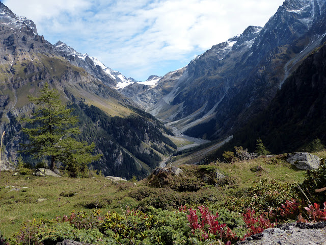
Ça y est, j'ai mis les pieds dans cette belle Gasteretal, coincée entre le Doldenhorn à gauche et le Balmhorn à droite. Belle atmosphère non ?

Alright, I'm in the Gasteretal, between Doldenhorn to the left and Balmhorn to the right. Very nice atmosphere isn't it ?


J'ai droit à 7-8 km de plat, entre pâturages et forêt.  Autant vous dire que je n'ai pas croisé grand monde...

I've got 7-8 km of flat trail, between pastures and forest. Needless to say, I didn't see much people...


Des nuages viennent troubler le moment, heureusement il ne resteront pas longtemps.

Clouds are trying to ruin the party but fortunately they won't stay too long.


La montée au Lötschpass débute. 1500 mètres au total depuis Kandersteg.

The climb to the Lötschpass starts. 1500 m up overall from Kandersteg.


Naturellement, la vue s'ouvre au fur et à mesure que je monte. On voit la fin de la Gasteretal et le début du glacier du Kanderfirn. De l'autre coté, c'est la haute vallée de Lauterbrunnen, visitée cet été (article).

Obviously, the view gets wider as you go up. We can see now the end of the Gasteretal and the Kanderfirn glacier. On the other side is the upper Lauterbrunnen valley, which I visited earlier this summer (article).


Petit coin de paradis, justement appelé Schönbüel. La montée continue tout droit en longeant les sapins sur leur gauche, pour passer l'ancienne moraine du glacier Lötschegletscher.

Very nice place, righlty called Schönbüel. The climb goes straight up, along the pine trees, to pass over the old moraine of the Lötschegletscher glacier.


Dernier coup d’œil sur la Gasteretal et le gros Doldenhorn. Le Mutthorn siège au milieu du glacier. Derrière sur sa droite, la belle Jungfrau. A gauche du Mutthorn, on voit le Gspaltenhorn et les Blümlisalp.

Last look over the Gasteretal and the big Doldenhorn. The Mutthorn is sitting in the middle of the glacier. Behind it and to its right is the pretty Jungfrau. To its left are the Gspaltenhorn and Blümlisalp.


Je laisse tout ça derrière et j'avance vers le glacier qu'on devine déjà. A fond, le Ferdenrothorn.

Moving on towards the glacier. On the background, the Ferdenrothorn.


Le chemin passe sur le glacier puis saute la barrière rocheuse à gauche, pour arriver au col. Parfois c'est pas évident de trouver la trace.

The trail crosses the glacier, goes over the rocks to the left hand side and then arrives to the pass. Sometimes following that trail wasn't easy.


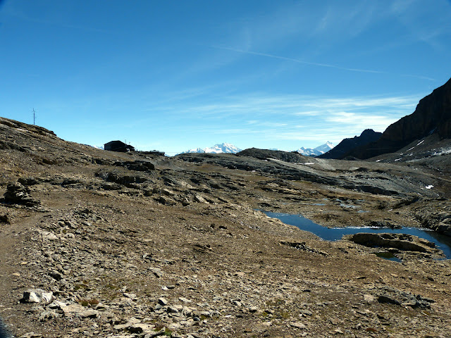
Plus que quelques mètres... De montée je veux dire ! Les alpes valaisannes pointent le bout de leur nez. Je commence à accélérer :-).

Just a few meters left. Well, uphill I mean ! The valaisan Alps are showing up.  Walking faster now :-).


La vue est assez sympa là haut.

Nice view over there. 


On commence à voir la crête qui sépare la Lötschental du reste du Valais, avec le superbe Bietschhorn en vedette.

Here's the ridge between the Lötschental and the rest of the Valais, with the almighty Bietschhorn. 


C'est assez photogénique ce Lötschpass...

Quite a photogenic place this Lötschpass...


Moutons de compét !

Coolest goat ever.


A mi-chemin de la descente, l'alpage de Kummenalp.

Half way downhill, the Kummenalp pasture.


Après une descente de 1300 mètres, j'arrive dans la belle Lötschental. Au fond, le petit col enneigé, le Lötschenlücke, sépare cette vallée du Grosser Aletschfirn, branche du gigantesque glacier d'Aletsch.

After 1300 m of downhill, I made it to the beautiful Lötschental. On the background the tiny snowy pass, the Lötschenlücke, separates the valley from the Grosser Aletschfirn, branch of the huge Aletsch glacier.


Pas été déçu ! Décors spectaculaires, variés et sauvages. On est à l'écart de tout. C'est long mais c'est bon.

I wasn't disapointed ! Spectacular, wild and diverse landscapes. Pretty isolated too. It's a long one but it's so worth it.

mardi 18 septembre 2012

Bunderspitz


La randonnée de cette semaine nous emmène Urs et moi d'Adelboden vers Kandersteg, en passant par le Bunderspitz (2546 m). Paysages superbes sur l'Oberland. On s'évite 600m de descente en prenant le minuscule téléphérique d'Allmenalp qui ramène à Kandersteg.

The hike this week took Urs and I from Adelboden to Kandersteg and up to Bunderspitz (2546 m). Gorgeous sceneries over the Oberland. We saved 600 m of downhill taking the tiny cable-car in Allmenalp which goes down to Kandersteg.

__________________________

Très facile à trouver. En arrivant sur Adelboden, se garer au pied du téléphérique principal. Les panneaux pour Kandersteg sont tout prêts. 

Easy to find. In Adelboden, the trail starts near the main cable-car. The signposts to Kandersteg are very close.


Le Bunderspitz est visible déjà depuis Adelboden, au centre sur la photo. Sur la droite, le Gross Loner (3000 m). Paysage assez sympathique, des alpages et des chalets... Et l'atmosphère si particulière des beaux matins de septembre en montagne.

The Bunderspitz can be seen already from Adelboden, right at the center on that pic. On the right hand side, Gross Loner (3000 m). Nice landscapes, pastures and chalets. And that special atmosphere of these nice September mornings in the mountain.


Les chamois ont détalé trop vite cette fois ci. Des vaches ça vous va ?

Couldn't take pictures of chamois this time, they were far too quick. Are cows ok ?


On traverse un bout de forêt avant de sortir sur les alpages d'altitude. En bas, Adelboden. Première fois que je venais en été tient... Me suis cassé un poignet en surfant là-bas !

We went through the forest before getting to the mountain pastures. Down there is Adelboden. Never been before in summer btw. Broke a wrist snowboarding over there!


Déjà occupé à chercher la prochaine rando !

Already searching for the next hike!


Un peu de hors-piste pour faire la jolie photo. Au fond, c'est le Wildhorn, Diablerets etc. Lenk et Gstaad ne sont pas bien loin.

Nice isn't it? On the background are Wildhorn, Diablerets etc. Lenk and Gstaad are not far away either.


Le sommet approche.

Summit getting close.


La vue s'ouvre soudainement. Sympa nan ? Sur la droite, la pyramide du Doldenhorn  (3638 m) surplombe le magnifique Oeschinensee. Derrière, le massif des Blümlisalp. Tout au fond, on devine la trilogie Eiger, Mönch et Jungfrau. En bas c'est Kandersteg. L'Oberland bernois c'est quelque chose...

Suddenly the view got great. The nice white pyramide on the right side is the Doldenhorn (3698 m), towering above the magnificent Oeschinensee. Behind is the Blümlisalp. On the background we see the famous Eiger, Mönch and Jungfrau trilogy. Down there that's Kandersteg. The bernese oberland is quite something...


En zoomant un peu sur la trilogie... 

Zooming a bit on the trilogy...


Derrière, Adelboden et le chemin déjà parcouru.

Behind, Adelboden and where we came from.


Au nord de la Bunderspitz, l'attirante crête d'Allmengrat. J'ai tenté de la prendre un peu mais c'est plus compliqué qu'il n'y parait... J'ai du capituler et descendre à flan de montagne :-(. Fallait pas rater une marche. Au fond, on devine le Niederhorn au centre et le Niesen à gauche.

To the north of the Bunderspitz, the attractive Allmegrnat ridge. I tried to follow it for a while, but it's a bit tougher than it seems... I eventually gave up and had to come straight down :-(. You don't wanna miss a step. On the background, the Niederhorn at the center and the Niesen to the left.


Un pano ? Ok, sur la gauche la fameuse crête donc. A droite du Doldenhorn (au centre), la très belle pyramide d'Altels, tout juste devant le Balmhorn. Les inititiés reconnaitront le Bietschorn (canton du Valais) entre Balmhorn et Doldenhorn, tout au fond.

A panorama ? Ok, the Allmegrnat ridge to the left. Right from the Doldenhorn (center) the very nice pyramid is Altels, just next to the Balmhorn. The experts will spot the Bietschorn (canton Valais) between these Balmhorn and Doldenhorn, on the background.


Après une descente un peu raide au début, on arrive à Allmenalp. Tout petit téléphérique mais à l'arrivée l'un des plus impressionnants que j'ai pu prendre. 400 mètres de vide sous les pieds !

After a steep downhill at first, we made it to Allmenalp. Tiny cable-car but at the end one of the most impressive one I took so far. 400 meters vertical drop!


Facile et donnant des paysages assez spectaculaires. Me suis régalé... En même temps, il n'y avait pas un nuage...


Easy with pretty spectacular landscapes. Really enjoyed that one. Well, the weather probably helped a bit...

N

samedi 8 septembre 2012

Glattalp - Ortstock

Que fait-on quand le soleil pointe le bout de son nez après un été pourri ? On prends sa journée et on part randonner.  J'avais l'Ortstock sur ma liste depuis quelques temps. Je l'avais pris en photo en 2008 depuis Braunwald, dans le canton de Glarus, par une belle journée d'hiver:

What to do when the sun finally shines after a crappy summer ? You take the day off and go hiking. I had the Ortstock on my to-do list for a while. I took a picture of it in 2008 from Braunwald, in canton Glarus, on a nice winter day:


Pour varier la rando, je suis parti de Glattalp, au fond de la Bisistal, une vallée latérale de la Muothatal dans le canton de Schwyz. Un joli alpage, un lac (le Glattalpsee) et un sommet à 2717 m, sympathique programme.

I started from Glattalp, at then end of Bisistal, a lateral valley to the Muothatal, in canton Schwyz. A nice pasture, a lake (Glattalpsee) and a summit at 2717m. Quite a nice agenda.


Route


Départ de Glattalp (1892 m) au sommet du téléphérique partant de Sahliboden, au fond de la Bisistal. Une benne toute les 30 min et on évite 700 mètres de montée (et descente au retour) pas forcément nécessaires... Suivre Ortstock, puis Braunwald, Charetalp (la vallée parallèle au nord) et à nouveau Glattalp. La montée à l'Orstock est optionnelle mais c'est le clou du spectacle...

Start from Glattalp (1892 m) at the top of the cable car which starts in Sahliboden, at the end of the Bisistal. It goes every 30 min and you save 700 m up (and down on the way back) you don't really need. Follow Ortstock, then Braunwald, Charetal (the valley to the north) and finally Glattalp again. The way up to the Ortstock is optional but that's the main highlight...


Photos


Il est 8.30 et une belle journée s'annonce. Devant, l'alpe de Glattalp. Tout au fond un grand col (le Furggele). L'Ortstock, c'est la bosse à droite du col.

It's 8.30am and it's look good. Ahead is the pasture of Glattalp. On the background you see a big saddle, Ortstock is the next mountain to the right. 


Une belle lumière, pas de vent et un peu d'eau, ça fait des jolies photos...

A nice light, no wind and some water, here's your nice pics...


Glattalpsee.


La montée au col débute. Je risque pas de me perdre, le chemin est balisé depuis les airs dans ce canton apparemment.

The climb to the pass starts. I can't get lost, in this canton they seems to use air signposting.


La montée est très raide et sur un pierrier. La ferai pas par temps de pluie... A mesure qu'on monte, la vue sur la Suisse centrale s'élargit.

The climb is steep and on a scree. Wouldn't do it on a rainy day... As I go up, the view on central Switzerland gets wider. 


Arrivé au col, je jette un coup d’œil de l'autre coté, vers l'est. On voit un bout de Braunwald en bas. Plus bas, la vallée de Glarus. Tout au fond le Sarganserland.

Ok, made it to the pass. Quick peep on the other side, towards east. We can see a piece of Braunwald and further down the Glarus valley. On the background is the Sarganserland.


La montée au sommet reste raide jusqu'en haut. Un seul passage un peu technique avec une corde, sinon rien de dangereux.

The climb stays steep to the top. Only one technical part with a rope, otherwise nothing dangerous, really.


Me voila au sommet. Vue à 360° de toute beauté. Au sud-ouest, le plus grand alpage de Suisse, Urner boden. Au bout, les premiers lacets du magnifique Klausenpass. Derrière les montagnes, débutent les Grisons. Le Tödi (3614 m) trône au milieu de ce paradis.

Here I am at the summit. Stunning panoramic view. Towards south-west is the biggest Swiss mountain pasture, Urner Boden. At the end, the first hairpin turns of the magnificent Klausenpass. Behind the mountains, starts canton Grisons. The Tödi (3614 m) towers above this paradise.


A l'ouest, une bonne partie de la Suisse centrale. Le Glattalpsee en bas.

To the west, a fair part of central Switzerland. The Glattalpsee at the bottom.


Au nord-ouest, le plateau Suisse. On voyait pas le Jura ce jour là. On voit par contre bien le Rigi en noir à gauche et les Mythens au centre. On devine le lac de Zug et un bout de la Muothatal tient...

Looking north-west, the Swiss plateau. We couldn't see the Jura mountains on that day though. You can definitely see the Rigi in black on the left side, and the Mythens at the center. You can also guess lake Zug and a piece of the Muothatal.


Vers l'est, Braunwald en bas et le reste du canton de Glarus. On voit Schwanden au début de la Sernftal, l'autre vallée du canton de Glarus.

To the east, Braunwald at the bottom and the rest of canton Glarus. There's also Schwanden, where the Sernftal, the other Glarus valley, starts.


Je redescend, en retournant au col Furggele puis direction Braunwald. Encore un pierrier à pic. Arrivé en bas, à l’étendue herbeuse, je bifurquerais à gauche entre les deux montagnes, direction Charetalp.

Going downhill, first back to the Furggele pass and then towards Braunwald. Another very steep scree... When facing the large grass area, I'll turn left between the 2 mountains, towards Charetalp.


Début septembre, la flore se fait rare mais un majestueux chamois rattrape le coup.

It's early September, not so many flowers anymore but a majestic chamois made it up for me.


Coup derrière mon épaule vers le col d'où j'arrive.

Looking back from where I came.


La Charetalp est assez différente de Glattalp. Paysage très karstique.

The Charetalp valley is quite different from Glattalp. Karstic landscape.


Immense marécage d'altitude, bordé par des collines karstiques. Original et joli.

Huge high-swamp with karstic hills on the edge. Unusual and nice.


J'arrive du bout de cette vallée. Glattalp est derrière les montagnes à droite. Je monte pour y retourner.

I came from the end of the valley. Glattalp is behind these mountains to the right side. I'm going up now to get back to it.


Fin de la petite montée et descente vers le téléphérique à Glattalp. Dernier coup d’œil sur la vallée avec l'Ortstock (à droite du gros col si vous avez bien suivi).

The tiny uphill is over now and I'm going down again to the cable-car in Glattalp. Last look on the valley, with the Ortstock (to the right of the big saddle, you know that now).


A faire par beau temps sinon c'est gâché et très glissant. Paysages vraiment superbes. Les deux vallées sont différentes. Il m'a semblé que la montée à l'Orstock était assez populaire: Gruezi count assez élevé pour un vendredi de septembre. Mais il faisait tellement beau... Bref, très jolie randonnée.

To do when the weather is good, otherwise it's a waste and very slippery. Gorgeous scenaries. The 2 valleys have a different taste. Seemed to me that the climb to Ortstock was popular: Gruezi count pretty high for a Friday in September. The weather was great though... Anyway, really nice hike.


Nicolas.