dimanche 29 juin 2014

Fronalpstock

Le 1er août 2011, j'ai célébré la fête nationale suisse par un joli sommet de Suisse centrale, la Fronalpstock (1921 m).

On 1st of August 2011, I celebrated the Swiss national day with a nice climb in central Switzerland, the Fronalpstock (1921 m).

______________________________

Au dessus de Morschach, parking du téléphérique. Direction Stoos, puis Chligenstock (parfois orthographié Kligenstock) et Fronalpstock avant de redescendre par télésiège et téléphérique. Une alternative est de prendre le funiculaire vers Stoos qui démarre à l'entrée de la Muotatal.

Parked above Morschach, by the gondola. Walked towards Stoos then Chligenstock (sometimes spelled Kligenstok) and Fronalpstock. Downhill with chair lift and gondola. There's also a funicular going to Stoos, at the entrance of the Muotatal valley.


Passage par la forêt en montant vers Stoos. En ce beau matin d'été, lumière et brouillard font un joli duo.

Crossing the forest on my way up to Stoos. This was a lovely summer morning, sun and fog made a nice duo.


Une fois au dessus des nuages, nouvelle récompense: les Mythens (Kleiner et Grosser). Une belle montagne ce dernier, gravie avec Dante il y a quelques années.

Above the clouds, I got a nice reward: the Mythens (Kleiner and Grosser). The Grosser Mythen is a nice mountain, climbed some years ago with Dante.


Je passe au dessus de Stoos, petite station sympa, offrant des activités été et hiver.

Passing Stoos, nice little summer & winter resort.


L'alpage est assez grand, les dizaines de vaches m'offrent un sacré concert de cloches. Au fond à droite, la belle Glärnisch (2914 m).

The pasture is a big one, dozens of cows playing with their bells, quite a show. On the background, the beautiful Glärnisch (2914 m).


Me voila sur la crête du Chligenstock. De l'autre coté, cette calme vallée c'est la Riemenstaldental. Alice et moi étions passés par là en 2013 en allant gravir le Chaiserstock (au centre sur la photo).

I'm now on the ridge of the Chligenstock. On the other side, this peaceful valley is the Riemenstaldental. Alice and I visited it in 2013 when we climbed the Chaiserstock (center, background).


Le Chligenstock c'est lui. Jolie colline de 1935 mètres. Il est aussi équipé d'un télésiège. En bas, au bout de la Riemenstaldental, c'est le lac des Quatre-Cantons. Vous conviendrez qu'on trouve pire endroit pour pique-niquer.

That is the Chligenstock. Nice little hill standing at 1935 meters, also equiped with a chair lift. Down there, at the end of the Riemenstaldental, that's lake Lucerne. I had my picnic there, you'll agree that I could have done worse.


Zoom sur le Chaiserstock et le Rossstock. C'est beau là bas aussi...

Zoom over the Chaiserstock and Rossstock. Another lovely area...


Dernier coup d’œil en finissant mon sandwich et j'y vais.

Ok, let me finish my sandwich and I'm on my way.


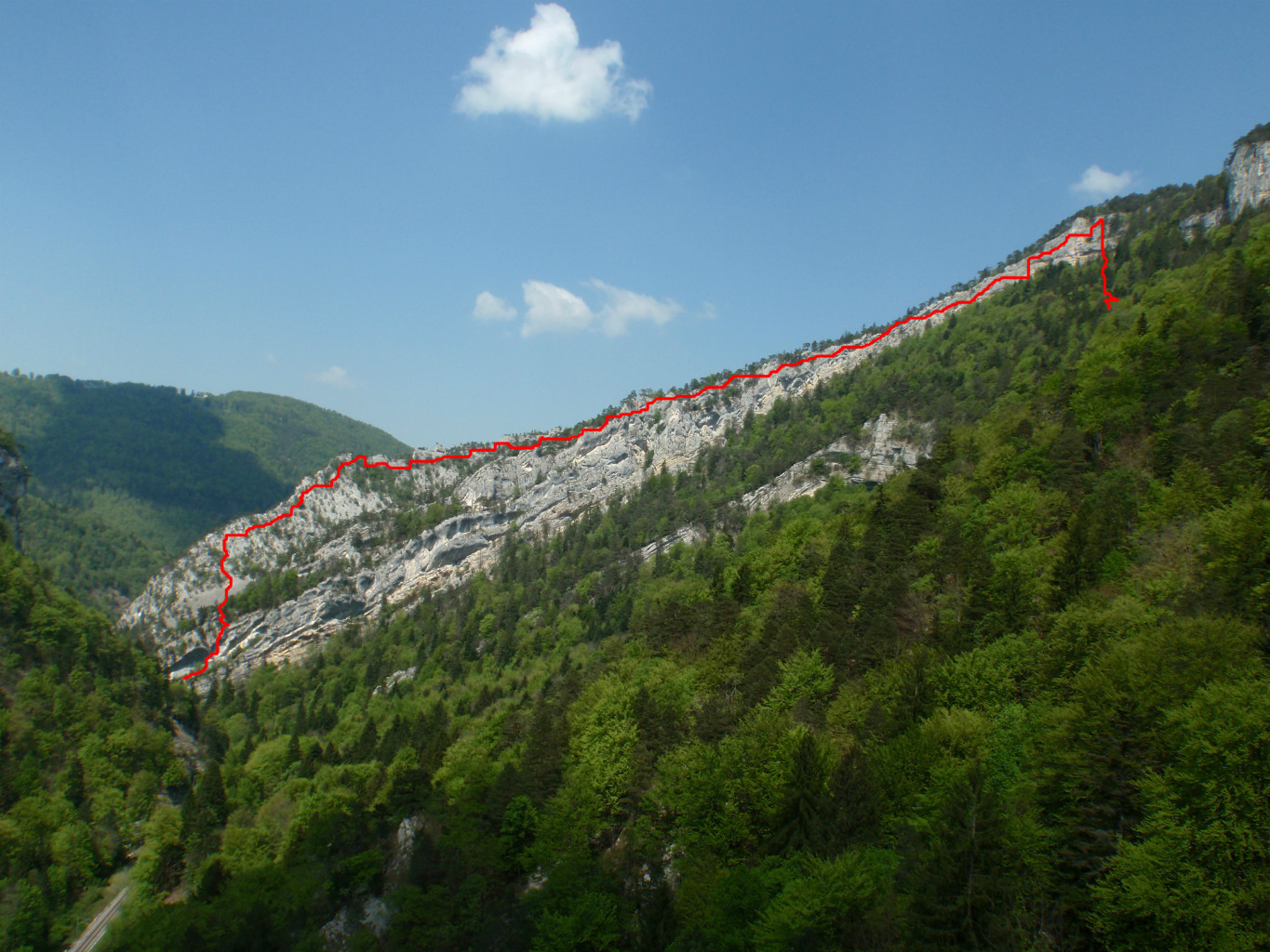
Entre Chlingenstock et Fronalpstock, une jolie crête sans danger. Un vrai régal.

Between Chligenstock and Fronalpstock, a safe little ridge. Really liked it.


Les Mythens toujours en vue.

Mythens still on sight.


Un 1er août je ne m'attendais pas à être seul. Grüzi count très élevé, surtout entre Chligenstock et Fronalpstock. C'est une ballade facile et populaire.

On a 1st of August, I didn't expect to be alone. Pretty high Grüzi count, especially between Chligenstock et Fronalpstock. It's an easy and famous hike.


Celle là, je la vois bien sur myswiterland.com :-). L'Uri Rotstock au fond, de l'autre coté du Lac. Derrière on trouve Engelberg.

That pic is very myswitzerland.com material :-). Uri Rotstock on the background. Engelberg is behind.


Probablement le plus beau lac de Suisse. A droite, on devine Seelisberg, visité en vélo en 2010.

Probably the nicest Swiss lake. On the right hand side, that's Seeliserg, which I visited with my bike in 2010.


La crête se termine bientôt. La croix et le sommet sont en vue.

The ridge will be soon over. Cross and summit are now on sight. 


Et m'y voila. Deux compétiteurs m'ont devancé.

Made it, though I had some tough competition.


Tout bon sommet de Suisse centrale est équipé de son drapeau et son restaurant. Vous sentez les bratwursts ?

Every proper summit in central Switzerland is equiped with a flag and a restaurant. Can you smell the bratwursts ?


Descente vers Stoos en télésiège. Le repos du guerrier.

Chairlift toward Stoos. Taking it easy.


Superbe promenade, comme toujours autour du lac des Quatre-Cantons. Ça me donne envie d'y retourner tient...

Great hike, as always around Lake Lucerne. I wanna go back !

N

Arête du Raimeux

Le Mont Raimeux est le point culminant du canton du Jura, à 1302 mètres. Un peu à l'ouest, une belle arête monte vers son sommet. C'est de l'escalade mais rien de bien méchant. Cotation libre 5b et obligatoire 3a.

Mont Raimeux is the highest peak of canton Jura with its 1302 meters. A nice ridge reaches the summit from the west. It's climbing but nothing impossible. Free climb grade is 5b and required is 3a.


Topo CamptoCamp.


+800 m (400 'difficile'). 3 heures pour monter, 1h30 pour redescendre.
+800 m (400 'difficult'). 3 hours to go up, 1h30 to go down.


Se garer au départ de la crête, sur la route entre Delémont et Moutier, au sud de Roches.

You can park at the bottom of the ridge, on the road from Delémont to Moutier, south of Roches.


Le départ de l'arête.

Beginning of the ridge.


Après 5 min d'approche sur un sentier, une grande dalle deversante et lisse annonce le vrai départ. Au niveau des arbres, c'est un pierrier. Si quelqu'un vous précède, c'est douche de pierres garantie. Casque conseillé...

After 5 min walking on a tiny trail, a big smooth and inclined slab to get started. See the trees up there ? There's a scree. So if someone's above, it's rocks shower guaranteed. Helmet is advised...


C'est assez pentu finalement, pas beaucoup de prises évidente. Avec des chaussons d'escalades ça passe tout seul, mais voila, j'ai fait mon malin et n'ai pris que des tennis... Une leçon de plus.

It's pretty steep after all, not so many obvious holes. With climbing shoes that would be easy, but I'm an idiot and only took trainers. Another lesson learnt.


On prends de la hauteur. Derrière c'est Moutier.

Getting higher. Behind that's Moutier.


Notez l'aptitude à regarder vers l'avant.  Impressionnant non ?

Notice the ability to look forward. Impressive isn't it ?


Dante pose aussi. C'est une très jolie crête en fait. Avec une belle ambiance calcaire et pins maritimes. On se croirait presque à Cassis !

Dante can strike a pose too. Very nice ridge actually.  Beautiful chalky atmosphere and pin trees. Almost feels like Cassis!


Le seul passage obligatoire vraiment délicat est équipé, façon via ferrata mais sans câble. Arête équipée de quelques spits quand il faut.

The one required tricky bit was equiped, via ferrata style but just without cable. In general the whole ridge was nicely equiped.


Quelques passages en 5a.

Some 5a sections.


C'est fini ?

Climb's over ?


Non, l'arête se poursuit assez longtemps, de ressaut en ressaut. Vraiment agréable à grimper et jamais très dure.

Nope, the ridge continues for quite a long time from a projection to another. Feels really nice to climb and it's never really hard.


Mais j'ai bien sûr un professeur de classe mondiale !

But of course I have a world class teacher!


La pluie était prévue et pour une fois la météo ne s'est pas trompée. On a du faire la partie haute (plus de la marche que de l'escalade) au pas de charge pour devancer l'orage. Le sentier n'est pas évident à suivre et on s'est perdu un moment. Descente dans la combe du Pont. Trempés :-).

Weather forecasts said rain and for once they were right. We had to rush the upper part to avoid the storm. Upper part is anyway more walking than climbing. The trail wasn't easy to follow and of course we got lost for a while. We came down in the 'combe du Pont'. Soaked :).


Après 5 heures et la fin du sentier, retour à la dalle de départ. Mouillée, ça doit pas être évident à monter :-)

At the end of trail and after 5 hours, back at the big slab. All wet and slippery, probably not easy to climb now :-).


Arête super sympa à faire. Idéal pour s’entraîner à jouer avec la corde, les nœuds et les techniques d'assurage. On reviendra pour explorer un peu plus !

Very cool ridge. Ideal for practicing the knots, playing with the rope and belaying techniques. We'll come back for more exploration!

Nicolas

lundi 23 juin 2014

Glogghüs

Au programme de ce premier dimanche d'été, 3 sommets et une crête aérienne au dessus de Melchsee-Frutt, en Suisse centrale. La randonnée est classée T5, c'est sacrément raide et le faux pas est interdit. En cas de vertige, fermez immédiatement la fenêtre !

On the agenda for this first summer Sunday, 3 summits and a thin ridge above Melchsee-Frutt, in central Switzerland. Breathtakingly steep, rated T5, you cannot miss a step. If you feel dizzy, close immediately the window.

___________________________________


14 km, +1050m, -1050m. T5.

Wanderland calcule 5h20 mais sous-estime largement la technicité du tracé. Sur internet j'ai lu 8 heures. Et moi ? 4h10, déjeuner inclus :-).

Wanderland says 5.20h but greatly underestimates how difficult the path is. Internet guy said 8 hours. Me ? 4.10h, lunch included :-).


A l'arrivée du téléphérique, il ne faut pas marcher bien longtemps pour admirer le lac. A droite, deux des sommets prévus. Coté gauche, au fond, le Titlis.

After arriving in Melchsee-Frutt, it doesn' take long to enjoy the view over the lake. To the right, 2 of the 3 planned summits. To the left in the background, the Titlis.


Jolie petite chapelle. Moi je me dirige pile en face, vers le Balmeregghorn (2255 m). Petite montée tranquille pour démarrer.

Nice little chapel. I'm going straight ahead now, towards Balmeregghorn (2255 m). Easy warm up.


A l'est, le classique de Suisse centrale, le Titlis. 

Looking east, the central Switzerland classic, mount Titlis.


La montée est vite avalée et je me retrouve avec une jolie vue. En face, on trouve le Huetstock et Graustock. En bas, on voit le Tanensee. Tout à droite, le petit bout de lac au dessous du Jochpass c'est l'Engstlensee.

I quickly went up and found nice views. Ahead, that's Huetstock and Graustock . Down there we see the Tanensee. To the right hand side, there's a piece of Engstlensee, below Jochpass.


La montée depuis Melchsee-Frutt. Au fond, le Pilatus.

The way up from Melchsee-Frutt. On the background, the Pilatus.


Les difficultés commencent et les balises rouge cèdent leur place aux bleus. Le chemin passe par les crêtes jusqu'au champ de neige en haut puis, toujours sur le crête, vers le sommet au fond à droite.

Ok, easy part's over, the red markers will turn blue. The path follows more or less the ridge up to the snow fields and continues towards the summits to the right hand side.


Le Rothorn (2525 m), premier sommet de la journée. Encore un Rothorn pour ma collection :-).

Rothorn (2525 m), first summit today. Another Rothorn for my collection :-).


On voit la croix du Rothorn à gauche et celle du Glogghüs à droite. Entre les deux, un joli col bien raide, ça promet :-).

See the Rothorn's cross (left) and Glogghüs' one (right) ? Between these two, a nice steep pass, looks interesting :-).


C'est pas de la randonnée ici, carrément de l'escalade, niveau 2 certes. A ce moment, on est sur une crête où il vaut mieux ne pas tomber.

This is no hiking here, rather climbing, I'd rate it 2 though. Thing is, you start from a ridge where falling would be a bad idea.


Au moins la vue est top (vers l'est ici).

At least the view is great (looking east here).


Arrivé sur la crête, j'ai droit à la vue vers l'ouest. L'Oberland est dans les nuages. On devine quand même plein de choses: la chaine des Engelhorner, Grosse Scheidegg, un bout de l'Eiger, le Schwarzthorn et le Brienzersee. En dessous on voit Mägisalp et Planplatten, visités avec Urs quelques années auparavant.

Once on the ridge, I was granted views to the west. The Oberland is clouded, still there's lot to see: the Engelhorner range, Grosse Scheidegg, a piece of Eiger, Schwarzthorn and the Brienzersee. Belows, that's Mägisalp and Planplatten, visited a few years ago with Urs.


Les eaux turquoises du beau Brienzersee. Tout à gauche, le Niesen.

The turquoise waters of the beautiful Brienzersee. To the left hand side, the Niesen.


Plus au nord et facile à repérer, la longiligne Schrattenflue. Plus à gauche, la pyramide du Brienzer Rothorn et Höch Gumme.

More to the north, very easy to spot, the slender Schrattenflue. To its left, the Brienzer Rothorn pyramid and Höch Gumme.


Le Rothorn est en vue, suivi par Glogghüs et Hochstollen. C'est parti !

The Rothorn is on sight, followed by Glogghüs and Hochstollen. Here we go!


Sommet du Rothorn, avec le Melchsee en bas et toujours le Pilatus en fond de carte postale.

Top of the Rothorn, Melchsee is down there, Pilatus still on background of that postcard.


Toujours le Rothorn mais de l'autre coté, après la descente et la remontée vers Glogghüs. Bien raide ! Quelque câbles pour aider. J'ai vu des gens en mode via ferrata et grosses chaussures. Moi j'étais léger, en mode trail !

Rothorn again but from other side. I went down and up again towards Glogghüs. Very steep ! Some cables are here to help. I saw some people with big boots using the cables like in a via ferrata. I was going light, trail style!


Presque arrivé au Glogghüs. Autant vous dire qu'ici on regarde où on met les pieds. Pierres instables et crête assez étroite

Almost made it to Glogghüs. Needless to say, you need to watch your steps. Loose stones and fairly thin ridge.


La croix du Glogghüs et les crêtes que je viens de prendre.

Glogghüs' cross and the ridges I just took.


Gros plan vers le sud-ouest. La vallée Urbatal, visitée avec Jonas en vélo il y a quelques années. Et la chaîne, grisâtre, des Engelhorner où Dante est en train de grimper à ce moment même. J'ai zoomé mais j'ai rien vu :-).

Zoom to south-west. Urbatal valley, Jonas and I cycled there some years ago (remember ;-) ?). Then the greyish Engelhorner, where Dante was climbing this very day. I zoomed and I zoomed but didn't see anything. You were drinking at the hut weren't you ?


Suivant !

Next!


La descente depuis Glogghüs, bien équipée aussi.

Downhill from Glogghüs, well equiped too.


Le Hochstollen donc, troisième et dernier sur ma liste ce jour là. Le chemin, beaucoup moins vertigineux que les 2 autres, y monte depuis la gauche. On redescend sur Melchsee-Frutt par ce sentier visible à droite.

So that's the Hochstollen, third and last summit for the day. The path is much easier there, going up from the left side. You can see the path down to Melchsee-Frutt to the right side.


Trou assez original. J'ai pas pu m’empêcher de passer dedans. Le lac de Brienz au fond.

Funny hole. I couldn't help myself and went through it. Lake Brienz on the background.


Je vous épargne les détails, me voila en haut du Hochstallen avec vue sur 4 lacs: Blausee, Melchsee, Tanensee et Engstlensee. Sur la droite, la crête empruntée.

Ok, long story short, I'm at the top of Hochstallen, looking at 4 lakes: Blausee, Melchsee, Tanensee and Engstlensee. On the right hand side, the whole ridge.


La Schrattenflue dans toute sa longueur.

Strechted Schrattenflue.


Descente au pas de course sur Melchsee-Frutt. Ils agrandissent la station mais ça reste vraiment tout petit. L'atmosphère reste très suisse, on y croise assez peu de touristes étrangers là bas.

Running back down to Melchsee-Frutt. The resort is getting bigger but it's still quite tiny. Atmosphere is still very swiss, you don't hear many foreigners over there.


Une demie heure après le sommet, me voici au Blausee, à contempler ce Hochstallen.

Half an hour after topping, I'm at the Blausee, staring at this Hochstallen.


Et retour au téléphérique avec un pano sur tout le chemin parcouru.

And back at the Gondola. Here's a panorama of the whole hike.


Une bien belle région Melchsee-Frutt. Je n'étais pas venu en été depuis facilement 6 ans. J'ai eu tort ! Plein de choses à faire là bas.

Melchsee-Frutt is a lovely area. First time in  6 years since I've been there in summer. That's wrong, lot's of things to do there.


N