
 J'avais remarqué le Hahnen lors d'une sortie avec Dante en 2014 sur les via ferrata au dessus d'Engelberg. Je l'avais trouvé bien joli et comme toujours j'attendais le bon moment. Pour sa dernière sortie suisse avant bien longtemps, me suis dit que ça serait bien d'emmener Dante là haut. Belle journée, sur une montagne sauvage.
 I noticed Hahnen back in 2014 when Dante and I did some via ferrata above Engelberg. I found it attractive and as always I was waiting for the right time. For his last hike in Switzerland before a long time, I thought it would make sense to take Dante up there. Cool day on a wild mountain.
Hahnen

Randonnée T3 balisée puis T5 non balisée.
T3 marked hike, then unmarked T5.
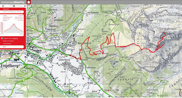
We left Engelberg early. One hour walking in the fog, heading to Over Zieblen.

Belle ambiance de fin d'automne.
Frosty, late autumn atmosphere.

En face, la chaîne entre Rigidalstock (gauche) et Grosser Sättelistock.
In the distance, the range between Rigidalstock (left) and Grosser Sättelistock.

Titlis.

Voila la bête. On va d'abord se diriger vers le point 1909m, sur une petite sente, puis on contournera cette tour par la droite (point 2207).
Here's the beast. We'll first head to the point 1909m on a little trail and we'll go around that tower to the right (point 2207).

Ça monte dur !
Steep!

Derrière, la mer de nuage se dissipe, Engelberg apparaît. Au dessus, le Huestosck à gauche, puis Nünalphorn et Widderfeld Stock. Tout à droite, la longue crête qui mène au Stanserhorn.
Behind, clouds fading away, Engelberg appears. Above, Huestosck on the left , then Nünalphorn and Widderfeld Stock. To the right hand side, the long ridge that goes to Stanserhorn.

Sur cette croupe souffle un vent à décorner les bouquetins. Pas chaud !
Wind was blowing strong on that rounded ridge. Cold!

A cet endroit, il faut passer dans ces rochers à l'ombre et s’élever sur ces pentes herbeuses au dessus. Dante, les yeux rivés sur ses chaussures et une petite sente qui contourne le massif, passe à droite. Et moi je suis :-)
There you need to go over these rocks in the shade and walk on these grassy slopes above. Dante, staring at his shoes and a faint trail going around the whole range, missed the exit. And I followed :-)

Je sors le GPS et je nous ramène vers le point 2287 en passant sur ce pierrier, sur une très vague sente. Tout à coup, j'entends du bruit, un rapide coup d’œil pour voir des dizaines de grosses pierres qui dévale depuis la falaise. J'étais pile dessous. Juste le temps de me jeter contre la falaise pour éviter de me faire mitrailler. Par chance je m'étais rapproché de la falaise, délaissant la sente, sinon j'étais aplati... C'est passé pas loin cette fois. Bon instinct et bon réflexe mais belle frayeur. Je n'avais pas prix de casque car 'simple' randonnée. Dans cette situation le casque n'aurait rien changé mais je recommande néanmoins de le prendre ici... Bref, sur la photo je colle à la paroi à présent ^-^
GPS helped me to get back to point 2287, using that scree and a very faint trail. Suddenly, I heard something above and quickly realized that dozens of big stones were falling fast, right above me. I barely had time to jump and find shelter against the wall. Luckily I had left the trail to get close to the wall, otherwise... That was really close this time. Good instinct and reflex but quite scary. I didn't bring my helmet, because 'simple' hike. It would not have made a big difference in that situation but I recommend nonetheless to bring one there. So on the photo, I'm really sticking to the wall now ^-^

On descend un peu pour trouver le passage à prendre. Quelqu'un descends. La bon itinéraire depuis la vallée passe plus bas à gauche, il est cairné et avec une belle flèche bleue. Je suppose que Dante a voulu tester mes réflexes en passant par là !
Quick walk down to find the right passage. Someone is on his way down. The right trail from the valley goes below, on the left, there's cairns and a big blue arrow. I can only suppose Dante chose the hard way to test my reflex.


Quelques câbles, rien de dur. Je surveille les falaises maintenant :-)
Some cables, nothing tricky. Watching carefully the wall now :-)

Le sommet approche, on entame une dernière traversée vers l'ouest.
Summit is on sight, starting one last traverse to the west.


Ce passage est très bien équipé. Le couloir final se trouve juste sur la gauche.
This section is nicely equiped. The final couloir is just there, on the left.

Couloir également très bien équipé.
The couloir is also nicely equipped.


Et voila le travail !
There you go!


Vue imprenable sur cette belle arête entre le Rigidalstock et le Ruschstock. Derrière, c'est Bannalp. J'ai pas mal topoté cette arête. C'est un sacré challenge apparemment. Les copains, si vous lisez...
Cool views over that ridge between Rigidalstock and Ruschstock. Behind, that's Bannalp. I keep reading topos on that ridge, it's quite a challenge apparently.

Engelberg encore sous les nuages / still below the clouds.

Au sud-est, Wissberg au premier plan (surplombant Fürenalp) et les Spannort au fond à droite.
South-east: Wissberg (towering above Fürenalp) and the Spannort on the background.

A l'ouest, l'Oberland tout au fond (Engelhörner et Wetterhorn). On devine bien aussi le Schwarzhorn fait la semaine avant. Plus proche, Jochpass, Rotsandnollen, Huetstock. On devine le joli lac Trübsee.
Looking west, the Oberland all the way back there: Engelhörner, Wetterhorn and Schwarzhorn, which we did last week. Closer, Jochpass, Rotsandnollen, Huetstock and Trübsee.

A l'est, un terrain que je connaît mal. Uri Rotstock au fond.
East, a region I don't know well. Uri Rotstock in the background.

On s'attarde pas là haut, le vent souffle et ça caille bien. On redescend par le même chemin. J'entame le haut du couloir. Avec le câble, ça descend tout seul en marche arrière.
We didn't linger up there, pretty cold and windy. We came down the same way. That's me in the upper couloir. Easy and fast with the cable.


Traversée. On est toujours sur une sente.
Still on a tiny trail.


On s'est encore un peu perdu dans ces sentiers. Pause lunch avec la vue qui va bien.
We got lost again on these faint trail. Lunch break with a view now.

Fin facile sur sentier, et toujours cette vue superbe.
The rest is easy, still with great views.

Hahnen qui s'éloigne / getting away.


Passage en forêt, magnifique jeux de lumière.
Forest, beautiful light and colors.


Retour sur le plancher vert fluo des vaches.
Back on flashy green.


Revenu au départ. C'est haut et loin ce truc finalement ! On a mis 6 heures quelque chose je crois.
Back to the start. This thing is high and far actually! Took us 6 hours something I think.

Dante et moi sommes fans de Brian Greene, ce scientifique américain qui vulgarise mécanique quantique et autres mystères physiques. Dans un de ses livre où il parle du temps et de l'espace, il explique que les tranches de temps passé demeurent, immuables. Le corollaire c'est que Dante et moi sommes toujours là-haut, figés dans l'une de ces tranches de temps. Il habite aujourd'hui à l'autre bout de la terre mais il a laissé sa trace spatio-temporelle dans les Alpes suisses ;-). A part ça, jolie randonnée T5 dans une ambiance un peu sauvage. Amenez un casque et méfiez vous, ça peut parpiner.
Dante and I are fans of Brian Greene, that US scientist who writes cool books about quantum physics and other mysterious theories. In one of his book where he talks about space and time, he explained that time slices from the past remain, immutable. The consequence is that Dante and I are still up there, stuck in one of these time slices. Today he lives on the other side of the earth but he left his spacetime imprint in the Swiss Alps ;-). Apart from that, cool T5 hike in wild country. Bring a helmet and beware the falling rocks.
N


